Roots Ireland

Find your Irish Ancestors today with the Irish Family History Foundation online research service

Login Register Subscribe

  • Home
  • Search
  • My Account
  • Search by County
    • All Ireland
    • Co. Antrim
    • Co. Armagh
    • Co. Carlow
    • Co. Cavan
    • Co. Clare
    • Co. Cork (North)
    • Co. Derry
    • Co. Donegal
    • Co. Down
    • Co. Dublin (North)
    • Co. Dublin (South)
    • Co. Galway (East)
    • Co. Fermanagh
    • Co. Galway (West)
    • Co. Kerry
    • Co. Kildare
    • Co. Kilkenny
    • Co. Laois
    • Co. Leitrim
    • Co. Limerick
    • Co. Longford
    • Co. Louth
    • Co Mayo
    • Co. Meath
    • Co. Monaghan
    • Co. Offaly
    • Co. Roscommon
    • Co. Sligo
    • Co. Tipperary (North)
    • Co. Tipperary (South)
    • Co. Tyrone
    • Co. Waterford
    • Co. Westmeath
    • Co. Wexford
    • Co. Wicklow
    • Ships Passenger Lists
  • Blog and News
  • Help
    • Getting Started
    • Searching This Site
    • Online Sources
    • Sample Records
    • Church Records
    • Civil Records
    • Census Records
    • Land Records
    • Gravestone Inscriptions
    • Census Substitutes
    • Ships’ Passenger Lists
    • Links
    • How to apply for an Irish Passport?
Special Offer - 25% Discount on Annual Subscriptions until midnight Irish time on 31st March,
New Limerick Records Added : RC Baptisms and marriages 1901-1915; 1766 heads of households; CI Gravestone inscriptions; Wills; Evicted Tenants, national school teachers; WW1 Casualties; Vehicle Owners and more
Learn more about your Irish and Scots-Irish Ancestors in 2023 with the Ulster Historical Foundation
New records for Kerry: Dromtariffe marriages, 1832-1899 (1,806 records)

About County Tyrone


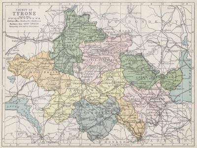
Tyrone covers some 3,155 km2, making it second in size only to Donegal in all of Ulster.  Situated at the heart of the province, it has land boundaries with Counties Armagh, Derry, Monaghan, Fermanagh and Donegal, and marches Antrim to the east along Lough Neagh. Only Cavan and Down do not adjoin it. The population in 2011 was approximately 178,000, about 20,000 less than it was in 1901. The chief mountains are the Sperrins, forming part of the boundary with Derry, with the highest peak (Sawel, 678m) partly in both counties. The main rivers are the Blackwater, Glenelly, Mourne, Strule and Camowen, while Omagh, Dungannon, Cookstown, Strabane and Fintona are the chief towns.

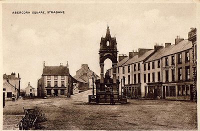
Abercorn Square, Strabane

Search Co. Tyrone Records


Search Co. Fermanagh Records

  • About Irish World Family History Service
  • About County Tyrone
    • Tyrone People
    • Tyrone History
    • Popular Tyrone Names
    • Tyrone Presbyterian Records
    • Tyrone Roman Catholic Records
    • Tyrone Church of Ireland Records
    • Tyrone Gravestone Inscriptions
  • About County Fermanagh
    • Fermanagh History
    • Fermanagh People
    • Fermanagh Names
    • Fermanagh Civil Records
    • Fermanagh Gravestone Inscriptions

Counties Online

Select your county from the map below

Online Now Not Online

View Larger Map

  • Home
  • Search
  • My Account
  • Search by County
  • Newsletters
  • Blog and News
  • Help
  • About Us
  • Contact our Centres
  • Terms and Conditions

Roots Ireland offers access to a unique database of more than 23 million Irish records

Irish Family History Foundation
Email: enquiries@rootsireland.ie

  • Facebook
  • Twitter

Copyright © 2023 Irish Family History Foundation ... All Rights Reserved

Design by Fingerprint Digital Media ... Powered by BRS Genealogy